The character of polygons and “patches” of cells or regions
How about of patches of other GIS identifiable entities like ore bodies, mountainous topography, forest patches, urbanized areas, etc. Much of this work comes from the forest ecology literature, as driven in part by the endangered species act. Starting with a polygon or raster representation of a single phenomenon (occurrence of oil spills) or a mapped area (land cover), one can learn about the area character of the regions. In the study of habitats, this is often related to species success through population studies.
Measures of shape include
- size and the distribution of sizes (e.g., what is the largest patch size relative to the mean of other patches with the same attributes)
- scale of patch sizes from Patch Analyst, a former ArcGIS plug-in
- shape
(e.g., area of patch vs area of circle/square/etc with same major diameter ) - compactness (e.g., perimeter vs area, or perimieter vs perimeter of circle of the same area)
Theobald, 2005, GIS Concepts and ArcGIS Methods gives it as

- thickness
- major and minor axes (imagine studying the orientation of dunes)
 from Wikipedia “dunes”
 - orientation
here’s a wild one for ya. Does the orientation of “carolina bays” (and some in Nebraska) tell us where the impact crater was….?
http://cintos.org/SaginawManifold/BearingCalc/index.html (note this is all programmed in Google Earth) - fragmentation ( a measure of the “brokenness” of the patches, perhaps measured by the number of regions divided by the number of cells of the map or zone.)
- centroids
- distance, inclusion, and “landscape signature”
Two programs Fragstats and Patch Analyst are full of details and possibilities.
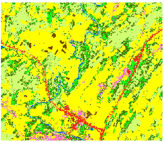
Here are some point and polygon spatial statistics from ArcGIS Pro. We will try a couple using the NLCD data in the demo folder “patch.”
- simplify the raster (7×7 Focal Stats Majority)
- convert to polygons
- determine the “Spatial Autocorrelation” — What does the output mean?
- convert the forests to polygon
- determine the “Average Nearest Neighbor” — What does the output mean?
and the “Directional Distribution” — What does the output mean?

