Haze Shift Correction (also known as “dark-pixel subtraction” or “atmospheric correction”)
Below are some histograms from a previous “demo” image queried using ERMapper (a remote sensing program we used to use until it was bought by another company that made it ridiculously expensive….). It is from Landsat 7 (so the sensor is TM+). What bands would these be in Landsat 8?

Note how the visual bands are shifted to the right. If you click in the darkest shadows on the image you can estimate the amount of haze shift in Red Green and Blue. This cartoon illustrates a scenario with haze.
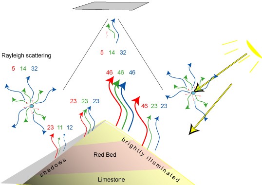
The blue “haze” is due to radiation scattered in by atmospheric molecules (mostly Rayleigh scattering ) that is received by the sensor in addition to radiation reflected by earth’s surface. It is most apparent for the shortest waveslengths (Landsat TM band 1, where it can be as much as 70 % of the return) and becomes insignificant in the IR bands. This correction should be used prior to constructing ratio and principal component enhancements discussed in following classes.
This process of image calibration and correction is a multi-step one with Landsat 8 and relies on the metadata (radiance correction) shipped with each image.

from humboldt.edu