Selecting Data Types (Raster vs Vector)
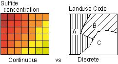
The number systems of spatial data are of several types and some are suited to raster representation, and some are suited to vector (after Theobald, 2007). Other decisions are necessary for image, terrain or the host of other types
- Qualitative or nominal data – discrete (1=basalt, 2=granite, etc for a geological map)
- Ordinal or rank data – discrete (low, medium, high; implies a quantity but is in “bins” or discrete categories)
- interval – continuous (e.g. Temperature)
- ratio – continuous (hillslope angle, which could be measured/calculated to any precision and reported in floating point values or integer values)
- cyclic – continuous (with a break at one or more points, like compass direction for the “aspect” of a hillslope)
Choosing the format for continuous vs discrete data types

Vector storage better for discrete and raster for continuous

Advantages/Disadvantages
| Vector | Raster |
|
|
Demo in ArcGIS
- view the grid vs polygon map in the introPro project
- change the transparency of the top layer, or swipe it away
- here the grid cell size is 200 m